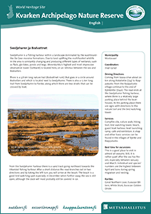
Kvarken Archipelago – Svedjehamn and Bodvattnet
Julkaisija
Metsähallitus,
Vantaa, 2014
Sivut
2 pp.
Kieli
Vaihtoehtoinen kieli
english
Tiivistelmä
Svedjehamn is a fishing harbour within a landscape dominated by the washboardlike De Geer moraine formations. Due to land uplifting the multifaceted wildlife in the area is constantly changing and producing different types of wetlands, such as flads, glo-lakes, ponds and bogs. Merenkurkku’s highest and most impressive observation tower (Saltkaret) is located here, on an isthmus between the sea and Bodvatten.
There is a 3,8 km long nature trail (Bodvattnet runt) that goes in a circle around Bodvatten and which is located next to Svedjehamn. There is also a 12 km long trail from Svedjehamn to Panike, along which there are two straits that can be crossed by boat.
Sähköinen julkaisu
Lisätietoja
Merenkurkun saariston maailmanperintöalueen englanninkielinen esite. Merenkurkku.
Lue lisää